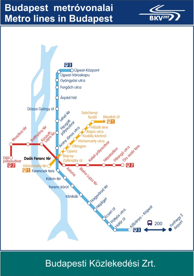
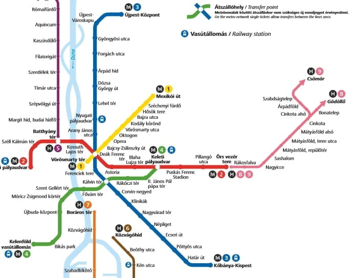
There are four metro lines in Budapest. The yellow is the oldest one, which is the second oldest subway/metro line in Europe. The red is the third, and the green line was opened on March 28th in 2014. On the map on this page, you can see all four metro lines, and you can also see the lines of some of the city trains (HEV lines) in Budapest.
You can see the maps in an even bigger version if you click on the maps. Enjoy your travel to Budapest using public transportation and the metro.
Do you want help to get from Budapest Airport to your hotel? Read more about our airport transfer service in Budapest here.
New Budapest Metro map with all four metro lines
Which metro line should you use to get to famous attractions, shopping malls, and other popular activities in Budapest? Here you have some examples:
Where to get off the metro in Budapest?
- The Parliament: Kossuth Lajos tér (red line).
- Széchényi Thermal bath: Szecheyi fürdő (yellow line).
- Vaci utca (shopping street): Vörösmarty tér (yellow line).
- Heroes Square: Hösök tere (yellow line)
- Big Market Hall: Fővám tér (green line)
- Allee Shopping Mall: Ujbuda kozpont (green line).
- West End City Center: Nyugati Palyaudvar (blue line).
- Arena Plaza: Keleti Palyaudvar (red/green line).
- Köki Terminal: Kobanya-Kispest (blue line).
- Árkád Mall: Őrz Vezér tere (red line).
- State Opera: Opera (yellow line).
- Puskás Arena/Budapest Sportarena: Puskás Ferenc Stadion (red line).
- Castle: Széll Kálmán tér (red line) – walk or take the bus from there.
- Hungarian National Museum: Astoria (red line), Kálvin tér (blue/green line)
- The big synagogue: Astoria (red line)
- New York Confectionary: Blaha Lujza tér (red line).
- Gerbeaud confectionery: Vörösmarty tér (yellow line)
Old Budapest Metro Map